


OpenStreetMap and GPS routes in the map on the web
April 28, 2011
The quality of the map assumptions in OSM has improved quickly from real nothing to this level,
that it has surpassed not only every naysayer's, but perhaps even most optimists' imaginations.
The progress of the project, and therefore the maps, has been so great in recent times,
that since 2010 not even googlmaps and not even the Czech leader mapy.cz from Seznam can compete with it.
I evaluate on the basis of where I am most often found, i.e. mapping of the Czech Republic.
Of course, there are probably places where this or that map could be better)
Apart from the classic advantage of a water-based solution, which is of interest mainly to more advanced users and then mainly to those who contribute to the project,
in this case, the benefits of openness will be appreciated more than usual by ordinary users.
The initial advantage is,
the maps are not tied to any software or technology of the map supplier.
From which further advantages follow:
- Maps can be viewed using a variety of even specialized programs for specific activities, often geocaching.
- They can be used on all sorts of devices. Can also be loaded onto common mass-market devices such as Garming.
- Offline use - no need to have internet all the time or pay for it.
- Different map formats - image tiles vs. vector format.
- Specialized maps for a specific activity, e.g. bike map, hiking map, large wall maps, etc.
- Maps designed for visual viewing only vs. for programming - typically navigation
Simply, these maps can be used everywhere and yet easily.
I can recommend Navit, TangoGPS and AGTL - advanced geocaching tool linux.
Using the OpenLayers.org project
can then be made easy to display on the web.
Example of basic map usage and adding a marker to the map:
OpenStreetMap web view
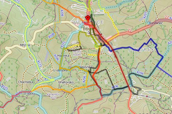
A more advanced example of plotting a route on a map:
GPX view in OpenStreetMap
You can easily do what you need, for example display a point or even a route.
For example, this is a graphically poor but useful view with the possibility of drawing routes into the map:
web display of route record from GPS in OpenStreetMap.
For a web "programmer", it will certainly be no problem to do very interesting things with all this.
In addition to HTML, at least some familiarity with JavaScript is useful.
and of course some web server side language usually PHP will help.
Video
Source code of sample web application with OSM implementationLivestream recording of how, where I showed how to implement OpenStreetMap in a web site:
Articles on a similar topic
How to speed up the web
Rector: upgrade PHP application
Go programming language
Analysis of assignment and pricing of software project development
Python program to control Docker using the API
How to use MailCatcher to test emails
Python OpenAI API
Creating a WebSocket web application and setting up a proxy
Project management: agile software development
How to run old PHP applications
What a good programmer should know
Rust programming language
NodeJS: development, server configuration
Nette security bug CVE-2020-15227
REST API: platform API
Custom web and mail hosting with ISP Config software
Programming in SQL: PostgreSQL, MySQL/MariaDB
HTTPS: secure web
NoSQL database Mongo DB
Connecting to Microsoft SQL Server from Linux
What is the job description of a programmer
Python application localization
Which mail and web hosting to choose
Digispark - Program Atmel ATtiny microcontroller with Arduino IDE
Development for ARM processors with Arduino IDE
How to program the ESP8266 WiFi processor
What platform should I choose for my e-shop? For example, Prestashop
Quickplay
Java Card OpenPlatform Contact and Contactless Chip Cards
Open smartphone with Linux - Openmoko Neo FreeRunner
Newsletter
If you are interested in receiving occasional news by email.
You can register by filling in your email
news subscription.
+